|
|
|||||||||||||||||
| Point ID: 6229 | Downloads | Plots | Site Data | Code: 3212 |
|
|
|||||||||||||||||
| Download | |
|---|---|
| Site Descriptor Information | Site Time Series Data |
| Link to all available data | |
| View: | Time Series | All |
| Units: | mm |
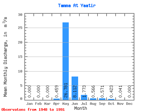
| Statistic | Jan | Feb | Mar | Apr | May | Jun | Jul | Aug | Sep | Oct | Nov | Dec | Annual |
|---|---|---|---|---|---|---|---|---|---|---|---|---|---|
| Mean | 0.00 | 0.00 | 0.00 | 0.46 | 26.78 | 8.11 | 1.77 | 0.57 | 0.57 | 0.42 | 0.04 | 0.00 | 3.27 |
| Standard Deviation | 0.00 | 0.00 | 0.00 | 1.95 | 26.94 | 9.39 | 2.55 | 0.62 | 0.74 | 0.73 | 0.12 | 0.00 | 2.69 |
| Min | 0.00 | 0.00 | 0.00 | 0.00 | 0.27 | 0.10 | 0.11 | 0.05 | 0.06 | 0.02 | 0.00 | 0.00 | 0.05 |
| Max | 0.00 | 0.00 | 0.00 | 12.50 | 95.20 | 48.00 | 12.10 | 2.53 | 3.02 | 3.87 | 0.54 | 0.00 | 10.52 |
| Coefficient of Variation | 4.26 | 1.01 | 1.16 | 1.44 | 1.10 | 1.30 | 1.74 | 2.88 | 0.82 |
 Return to R-Arctic Net Home Page