|
|
|||||||||||||||||
| Point ID: 6209 | Downloads | Plots | Site Data | Other Close Sites | Code: 3156 |
|
|
|||||||||||||||||
| Download | |
|---|---|
| Site Descriptor Information | Site Time Series Data |
| Link to all available data | |
| View: | Time Series | All |
| Units: | mm |
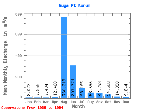
| Statistic | Jan | Feb | Mar | Apr | May | Jun | Jul | Aug | Sep | Oct | Nov | Dec | Annual |
|---|---|---|---|---|---|---|---|---|---|---|---|---|---|
| Mean | 8.07 | 7.56 | 7.40 | 12.46 | 760.32 | 307.77 | 93.17 | 53.70 | 47.79 | 34.57 | 14.36 | 9.84 | 113.61 |
| Standard Deviation | 2.79 | 2.44 | 2.32 | 9.23 | 268.57 | 201.58 | 68.52 | 53.29 | 32.85 | 19.51 | 5.96 | 3.91 | 33.85 |
| Min | 3.65 | 2.84 | 3.28 | 3.72 | 6.85 | 6.31 | 1.53 | 13.50 | 17.60 | 12.70 | 4.06 | 3.98 | 14.46 |
| Max | 20.50 | 13.50 | 13.80 | 57.70 | 1450.00 | 1070.00 | 301.00 | 336.00 | 173.00 | 95.20 | 37.10 | 28.10 | 199.29 |
| Coefficient of Variation | 0.35 | 0.32 | 0.31 | 0.74 | 0.35 | 0.66 | 0.73 | 0.99 | 0.69 | 0.56 | 0.41 | 0.40 | 0.30 |
| Other Close Sites | ||||||
|---|---|---|---|---|---|---|
| PointID | Latitude | Longitude | Drainage Area | Source | Name | |
| 6208 | "Nuya At Komaka" | 60.27 | 1367554 | SHI | 554.00 | |
| 6325 | "Nuya At Naakhara" | 60.45 | 1338820 | SHI | 244.00 | |
 Return to R-Arctic Net Home Page