|
|
|||||||||||||||||
| Point ID: 619 | Downloads | Plots | Site Data | Code: 07AF010 |
|
|
|||||||||||||||||
| Download | |
|---|---|
| Site Descriptor Information | Site Time Series Data |
| Link to all available data | |
| View: | Time Series | All |
| Units: | mm |
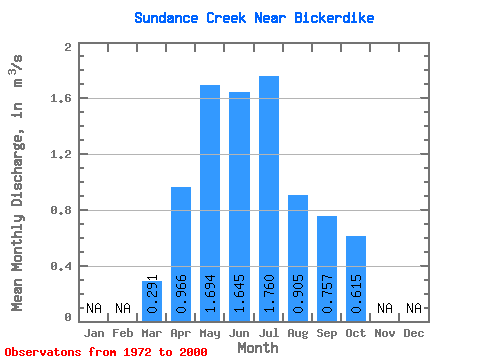
| Statistic | Jan | Feb | Mar | Apr | May | Jun | Jul | Aug | Sep | Oct | Nov | Dec | Annual |
|---|---|---|---|---|---|---|---|---|---|---|---|---|---|
| Mean | 0.29 | 0.97 | 1.69 | 1.65 | 1.76 | 0.91 | 0.76 | 0.61 | |||||
| Standard Deviation | 0.10 | 0.42 | 1.09 | 1.11 | 1.46 | 0.69 | 0.60 | 0.36 | |||||
| Min | 0.12 | 0.43 | 0.46 | 0.31 | 0.20 | 0.13 | 0.16 | 0.19 | |||||
| Max | 0.56 | 1.74 | 5.24 | 5.21 | 6.54 | 2.86 | 2.28 | 1.69 | |||||
| Coefficient of Variation | 0.34 | 0.43 | 0.64 | 0.68 | 0.83 | 0.76 | 0.79 | 0.58 |
 Return to R-Arctic Net Home Page