|
|
|||||||||||||||||
| Point ID: 6146 | Downloads | Plots | Site Data | Code: 3036 |
|
|
|||||||||||||||||
| Download | |
|---|---|
| Site Descriptor Information | Site Time Series Data |
| Link to all available data | |
| View: | Time Series | All |
| Units: | mm |
| Statistic | Jan | Feb | Mar | Apr | May | Jun | Jul | Aug | Sep | Oct | Nov | Dec | Annual |
|---|---|---|---|---|---|---|---|---|---|---|---|---|---|
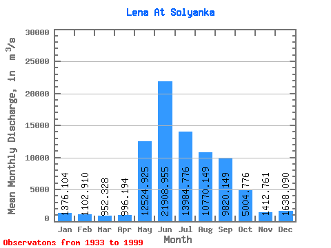
| Mean | 1376.10 | 1102.91 | 952.33 | 996.19 | 12524.92 | 21908.96 | 13984.78 | 10770.15 | 9820.15 | 5004.78 | 1412.76 | 1638.09 | 6791.01 |
| Standard Deviation | 255.94 | 228.82 | 213.83 | 265.24 | 3291.20 | 5357.71 | 4110.88 | 3412.16 | 3157.35 | 1335.61 | 353.64 | 274.74 | 1091.65 |
| Min | 857.00 | 677.00 | 577.00 | 625.00 | 5460.00 | 10600.00 | 6460.00 | 4490.00 | 3950.00 | 2570.00 | 839.00 | 992.00 | 4543.75 |
| Max | 2570.00 | 2090.00 | 2020.00 | 2090.00 | 23100.00 | 32400.00 | 26000.00 | 21100.00 | 18900.00 | 8680.00 | 2620.00 | 2440.00 | 9765.83 |
| Coefficient of Variation | 0.19 | 0.21 | 0.23 | 0.27 | 0.26 | 0.24 | 0.29 | 0.32 | 0.32 | 0.27 | 0.25 | 0.17 | 0.16 |
 Return to R-Arctic Net Home Page