|
|
|||||||||||||||||
| Point ID: 61 | Downloads | Plots | Site Data | Code: 05AC011 |
|
|
|||||||||||||||||
| Download | |
|---|---|
| Site Descriptor Information | Site Time Series Data |
| Link to all available data | |
| View: | Time Series | All |
| Units: | mm |
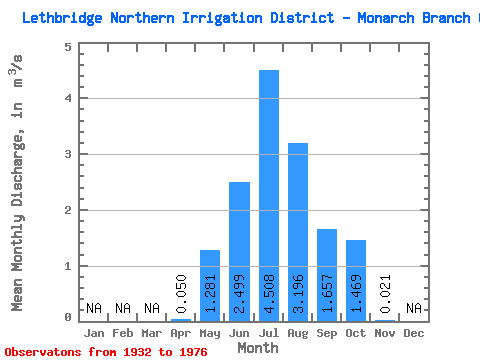
| Statistic | Jan | Feb | Mar | Apr | May | Jun | Jul | Aug | Sep | Oct | Nov | Dec | Annual |
|---|---|---|---|---|---|---|---|---|---|---|---|---|---|
| Mean | 0.05 | 1.28 | 2.50 | 4.51 | 3.20 | 1.66 | 1.47 | 0.02 | |||||
| Standard Deviation | 0.14 | 1.19 | 1.95 | 2.52 | 0.91 | 0.76 | 0.79 | 0.14 | |||||
| Min | 0.00 | 0.00 | 0.04 | 0.19 | 1.65 | 0.03 | 0.35 | 0.00 | |||||
| Max | 0.65 | 4.75 | 7.90 | 9.85 | 5.28 | 3.35 | 3.18 | 0.87 | |||||
| Coefficient of Variation | 2.89 | 0.93 | 0.78 | 0.56 | 0.28 | 0.46 | 0.54 | 6.40 |
 Return to R-Arctic Net Home Page