|
|
|||||||||||||||||
| Point ID: 6071 | Downloads | Plots | Site Data | Code: 7184 |
|
|
|||||||||||||||||
| Download | |
|---|---|
| Site Descriptor Information | Site Time Series Data |
| Link to all available data | |
| View: | Time Series | All |
| Units: | mm |
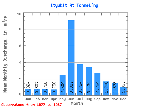
| Statistic | Jan | Feb | Mar | Apr | May | Jun | Jul | Aug | Sep | Oct | Nov | Dec | Annual |
|---|---|---|---|---|---|---|---|---|---|---|---|---|---|
| Mean | 0.82 | 0.81 | 0.77 | 0.75 | 2.50 | 9.09 | 3.76 | 3.43 | 2.75 | 1.71 | 1.57 | 1.06 | 2.43 |
| Standard Deviation | 0.35 | 0.18 | 0.20 | 0.16 | 1.62 | 2.89 | 2.12 | 2.02 | 1.16 | 0.48 | 1.17 | 0.24 | 0.49 |
| Min | 0.08 | 0.46 | 0.42 | 0.44 | 0.80 | 5.24 | 1.02 | 0.89 | 1.34 | 0.96 | 0.86 | 0.58 | 1.46 |
| Max | 1.29 | 1.13 | 1.15 | 0.95 | 5.69 | 14.10 | 7.32 | 7.52 | 4.79 | 2.31 | 5.02 | 1.44 | 3.29 |
| Coefficient of Variation | 0.42 | 0.23 | 0.26 | 0.22 | 0.65 | 0.32 | 0.56 | 0.59 | 0.42 | 0.28 | 0.75 | 0.22 | 0.20 |
 Return to R-Arctic Net Home Page