|
|
|||||||||||||||||
| Point ID: 6064 | Downloads | Plots | Site Data | Code: 7161 |
|
|
|||||||||||||||||
| Download | |
|---|---|
| Site Descriptor Information | Site Time Series Data |
| Link to all available data | |
| View: | Time Series | All |
| Units: | mm |
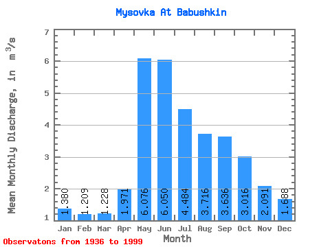
| Statistic | Jan | Feb | Mar | Apr | May | Jun | Jul | Aug | Sep | Oct | Nov | Dec | Annual |
|---|---|---|---|---|---|---|---|---|---|---|---|---|---|
| Mean | 1.38 | 1.21 | 1.23 | 1.97 | 6.08 | 6.05 | 4.48 | 3.72 | 3.64 | 3.02 | 2.09 | 1.69 | 2.95 |
| Standard Deviation | 0.39 | 0.41 | 0.35 | 0.57 | 1.88 | 3.35 | 2.23 | 1.34 | 1.51 | 0.92 | 0.61 | 0.42 | 0.60 |
| Min | 0.37 | 0.24 | 0.22 | 0.16 | 2.41 | 1.91 | 2.04 | 1.49 | 1.70 | 1.50 | 0.20 | 0.77 | 1.61 |
| Max | 2.25 | 2.35 | 2.11 | 4.41 | 10.70 | 25.20 | 11.80 | 7.55 | 9.81 | 5.95 | 3.56 | 2.52 | 4.44 |
| Coefficient of Variation | 0.28 | 0.34 | 0.28 | 0.29 | 0.31 | 0.55 | 0.50 | 0.36 | 0.42 | 0.30 | 0.29 | 0.25 | 0.20 |
 Return to R-Arctic Net Home Page