|
|
|||||||||||||||||
| Point ID: 6058 | Downloads | Plots | Site Data | Code: 7143 |
|
|
|||||||||||||||||
| Download | |
|---|---|
| Site Descriptor Information | Site Time Series Data |
| Link to all available data | |
| View: | Time Series | All |
| Units: | mm |
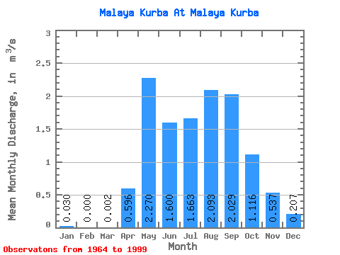
| Statistic | Jan | Feb | Mar | Apr | May | Jun | Jul | Aug | Sep | Oct | Nov | Dec | Annual |
|---|---|---|---|---|---|---|---|---|---|---|---|---|---|
| Mean | 0.03 | 0.00 | 0.00 | 0.60 | 2.27 | 1.60 | 1.66 | 2.09 | 2.03 | 1.12 | 0.54 | 0.21 | 1.12 |
| Standard Deviation | 0.04 | 0.00 | 0.01 | 0.33 | 1.17 | 1.35 | 1.25 | 1.42 | 1.66 | 0.55 | 0.29 | 0.14 | 0.53 |
| Min | 0.00 | 0.00 | 0.00 | 0.03 | 0.93 | 0.37 | 0.33 | 0.40 | 0.43 | 0.26 | 0.08 | 0.00 | 0.47 |
| Max | 0.14 | 0.00 | 0.02 | 1.20 | 6.74 | 7.82 | 6.78 | 5.78 | 9.82 | 2.44 | 1.26 | 0.50 | 2.37 |
| Coefficient of Variation | 1.42 | 2.51 | 0.55 | 0.52 | 0.84 | 0.75 | 0.68 | 0.82 | 0.49 | 0.54 | 0.68 | 0.47 |
 Return to R-Arctic Net Home Page