|
|
|||||||||||||||||
| Point ID: 6052 | Downloads | Plots | Site Data | Code: 7082 |
|
|
|||||||||||||||||
| Download | |
|---|---|
| Site Descriptor Information | Site Time Series Data |
| Link to all available data | |
| View: | Time Series | All |
| Units: | mm |
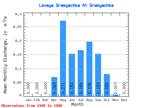
| Statistic | Jan | Feb | Mar | Apr | May | Jun | Jul | Aug | Sep | Oct | Nov | Dec | Annual |
|---|---|---|---|---|---|---|---|---|---|---|---|---|---|
| Mean | 0.00 | 0.00 | 0.00 | 0.07 | 0.27 | 0.15 | 0.17 | 0.20 | 0.15 | 0.08 | 0.01 | 0.00 | 0.09 |
| Standard Deviation | 0.00 | 0.00 | 0.00 | 0.05 | 0.21 | 0.14 | 0.15 | 0.19 | 0.13 | 0.07 | 0.01 | 0.00 | 0.05 |
| Min | 0.00 | 0.00 | 0.00 | 0.01 | 0.04 | 0.00 | 0.00 | 0.00 | 0.00 | 0.00 | 0.00 | 0.00 | 0.01 |
| Max | 0.00 | 0.00 | 0.00 | 0.23 | 1.25 | 0.69 | 0.69 | 0.82 | 0.50 | 0.30 | 0.05 | 0.00 | 0.20 |
| Coefficient of Variation | 4.95 | 0.69 | 0.78 | 0.93 | 0.90 | 0.96 | 0.82 | 0.84 | 1.59 | 0.52 |
 Return to R-Arctic Net Home Page