|
|
|||||||||||||||||
| Point ID: 5935 | Downloads | Plots | Site Data | Code: 1578 |
|
|
|||||||||||||||||
| Download | |
|---|---|
| Site Descriptor Information | Site Time Series Data |
| Link to all available data | |
| View: | Time Series | All |
| Units: | mm |
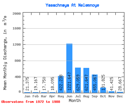
| Statistic | Jan | Feb | Mar | Apr | May | Jun | Jul | Aug | Sep | Oct | Nov | Dec | Annual |
|---|---|---|---|---|---|---|---|---|---|---|---|---|---|
| Mean | 21.38 | 19.17 | 17.75 | 18.09 | 422.24 | 1221.65 | 629.06 | 621.65 | 455.07 | 131.82 | 41.42 | 28.67 | 329.02 |
| Standard Deviation | 5.52 | 5.49 | 5.11 | 5.26 | 250.77 | 757.38 | 294.44 | 268.01 | 156.17 | 26.61 | 17.82 | 8.14 | 85.33 |
| Min | 12.60 | 10.30 | 10.20 | 8.44 | 39.10 | 515.00 | 273.00 | 240.00 | 274.00 | 85.90 | 5.40 | 14.60 | 188.13 |
| Max | 32.80 | 31.50 | 27.80 | 26.80 | 900.00 | 3170.00 | 1360.00 | 1220.00 | 748.00 | 187.00 | 80.20 | 42.50 | 499.61 |
| Coefficient of Variation | 0.26 | 0.29 | 0.29 | 0.29 | 0.59 | 0.62 | 0.47 | 0.43 | 0.34 | 0.20 | 0.43 | 0.28 | 0.26 |
 Return to R-Arctic Net Home Page