|
|
|||||||||||||||||
| Point ID: 5912 | Downloads | Plots | Site Data | Code: 1433 |
|
|
|||||||||||||||||
| Download | |
|---|---|
| Site Descriptor Information | Site Time Series Data |
| Link to all available data | |
| View: | Time Series | All |
| Units: | mm |
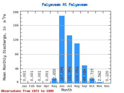
| Statistic | Jan | Feb | Mar | Apr | May | Jun | Jul | Aug | Sep | Oct | Nov | Dec | Annual |
|---|---|---|---|---|---|---|---|---|---|---|---|---|---|
| Mean | 0.00 | 0.00 | 0.00 | 0.00 | 12.65 | 187.10 | 131.96 | 110.06 | 49.08 | 12.72 | 2.56 | 0.12 | 42.16 |
| Standard Deviation | 0.00 | 0.00 | 0.00 | 0.00 | 13.42 | 81.36 | 39.89 | 45.27 | 21.24 | 8.07 | 1.19 | 0.21 | 9.64 |
| Min | 0.00 | 0.00 | 0.00 | 0.00 | 0.02 | 56.90 | 66.30 | 49.30 | 20.50 | 5.79 | 0.86 | 0.00 | 30.35 |
| Max | 0.00 | 0.00 | 0.00 | 0.00 | 35.30 | 400.00 | 206.00 | 198.00 | 128.00 | 49.40 | 5.20 | 0.88 | 71.70 |
| Coefficient of Variation | 0.00 | 0.00 | 0.00 | 0.00 | 1.06 | 0.43 | 0.30 | 0.41 | 0.43 | 0.64 | 0.46 | 1.73 | 0.23 |
 Return to R-Arctic Net Home Page