|
|
|||||||||||||||||
| Point ID: 591 | Downloads | Plots | Site Data | Code: 07AC001 |
|
|
|||||||||||||||||
| Download | |
|---|---|
| Site Descriptor Information | Site Time Series Data |
| Link to all available data | |
| View: | Time Series | All |
| Units: | mm |
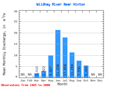
| Statistic | Jan | Feb | Mar | Apr | May | Jun | Jul | Aug | Sep | Oct | Nov | Dec | Annual |
|---|---|---|---|---|---|---|---|---|---|---|---|---|---|
| Mean | 2.01 | 2.92 | 9.81 | 21.24 | 17.86 | 11.28 | 7.59 | 5.40 | |||||
| Standard Deviation | 1.33 | 1.58 | 4.02 | 9.21 | 9.66 | 5.86 | 3.57 | 2.37 | |||||
| Min | 1.09 | 1.70 | 4.56 | 7.43 | 4.84 | 3.67 | 3.02 | 2.53 | |||||
| Max | 3.99 | 5.23 | 22.10 | 39.90 | 39.20 | 25.50 | 18.40 | 11.50 | |||||
| Coefficient of Variation | 0.66 | 0.54 | 0.41 | 0.43 | 0.54 | 0.52 | 0.47 | 0.44 |
 Return to R-Arctic Net Home Page