|
|
|||||||||||||||||
| Point ID: 5907 | Downloads | Plots | Site Data | Code: 1395 |
|
|
|||||||||||||||||
| Download | |
|---|---|
| Site Descriptor Information | Site Time Series Data |
| Link to all available data | |
| View: | Time Series | All |
| Units: | mm |
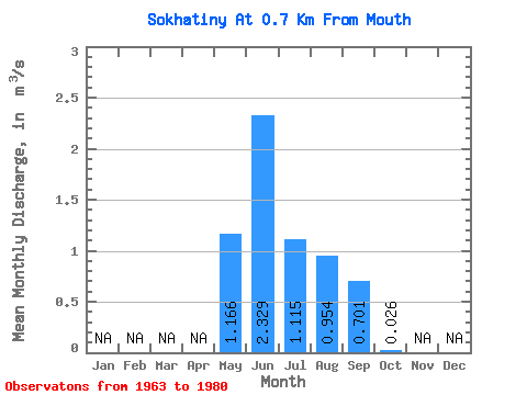
| Statistic | Jan | Feb | Mar | Apr | May | Jun | Jul | Aug | Sep | Oct | Nov | Dec | Annual |
|---|---|---|---|---|---|---|---|---|---|---|---|---|---|
| Mean | 1.17 | 2.33 | 1.11 | 0.95 | 0.70 | 0.03 | |||||||
| Standard Deviation | 0.68 | 1.21 | 0.68 | 0.54 | 0.46 | 0.02 | |||||||
| Min | 0.22 | 0.77 | 0.16 | 0.34 | 0.11 | 0.00 | |||||||
| Max | 2.30 | 5.19 | 2.89 | 2.48 | 1.91 | 0.08 | |||||||
| Coefficient of Variation | 0.58 | 0.52 | 0.61 | 0.57 | 0.65 | 0.87 |
 Return to R-Arctic Net Home Page