|
|
|||||||||||||||||
| Point ID: 59 | Downloads | Plots | Site Data | Code: 05AC009 |
|
|
|||||||||||||||||
| Download | |
|---|---|
| Site Descriptor Information | Site Time Series Data |
| Link to all available data | |
| View: | Time Series | All |
| Units: | mm |
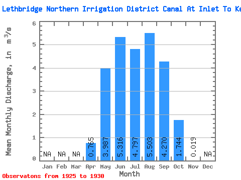
| Statistic | Jan | Feb | Mar | Apr | May | Jun | Jul | Aug | Sep | Oct | Nov | Dec | Annual |
|---|---|---|---|---|---|---|---|---|---|---|---|---|---|
| Mean | 0.77 | 3.99 | 5.32 | 4.80 | 5.50 | 4.27 | 1.74 | 0.02 | |||||
| Standard Deviation | 1.53 | 3.59 | 3.20 | 3.31 | 3.02 | 1.84 | 1.83 | 0.05 | |||||
| Min | 0.00 | 1.30 | 0.64 | 1.14 | 1.68 | 1.87 | 0.23 | 0.00 | |||||
| Max | 3.88 | 9.49 | 7.83 | 10.80 | 9.72 | 6.71 | 5.22 | 0.12 | |||||
| Coefficient of Variation | 2.00 | 0.90 | 0.60 | 0.69 | 0.55 | 0.43 | 1.05 | 2.45 |
 Return to R-Arctic Net Home Page