|
|
|||||||||||||||||
| Point ID: 5889 | Downloads | Plots | Site Data | Code: 1293 |
|
|
|||||||||||||||||
| Download | |
|---|---|
| Site Descriptor Information | Site Time Series Data |
| Link to all available data | |
| View: | Time Series | All |
| Units: | mm |
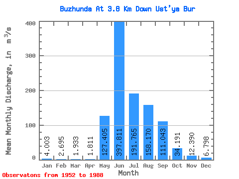
| Statistic | Jan | Feb | Mar | Apr | May | Jun | Jul | Aug | Sep | Oct | Nov | Dec | Annual |
|---|---|---|---|---|---|---|---|---|---|---|---|---|---|
| Mean | 4.00 | 2.69 | 1.93 | 1.81 | 127.41 | 397.81 | 191.76 | 158.17 | 111.04 | 34.19 | 12.39 | 6.80 | 85.09 |
| Standard Deviation | 2.10 | 1.41 | 1.14 | 1.00 | 92.08 | 191.55 | 97.41 | 73.89 | 67.91 | 15.98 | 5.67 | 3.79 | 21.91 |
| Min | 0.64 | 0.38 | 0.26 | 0.24 | 15.00 | 162.00 | 57.70 | 53.40 | 34.80 | 16.60 | 5.01 | 1.66 | 48.07 |
| Max | 9.17 | 5.26 | 5.34 | 4.39 | 442.00 | 1030.00 | 551.00 | 340.00 | 352.00 | 89.10 | 29.80 | 18.20 | 132.64 |
| Coefficient of Variation | 0.53 | 0.52 | 0.59 | 0.55 | 0.72 | 0.48 | 0.51 | 0.47 | 0.61 | 0.47 | 0.46 | 0.56 | 0.26 |
 Return to R-Arctic Net Home Page