|
|
|||||||||||||||||
| Point ID: 5888 | Downloads | Plots | Site Data | Code: 1289 |
|
|
|||||||||||||||||
| Download | |
|---|---|
| Site Descriptor Information | Site Time Series Data |
| Link to all available data | |
| View: | Time Series | All |
| Units: | mm |
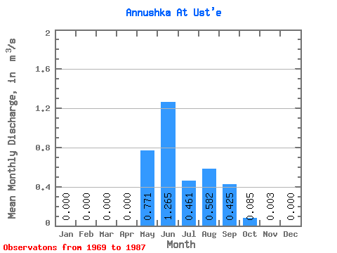
| Statistic | Jan | Feb | Mar | Apr | May | Jun | Jul | Aug | Sep | Oct | Nov | Dec | Annual |
|---|---|---|---|---|---|---|---|---|---|---|---|---|---|
| Mean | 0.00 | 0.00 | 0.00 | 0.00 | 0.77 | 1.27 | 0.46 | 0.58 | 0.42 | 0.09 | 0.00 | 0.00 | 0.39 |
| Standard Deviation | 0.00 | 0.00 | 0.00 | 0.00 | 0.47 | 1.05 | 0.35 | 0.42 | 0.27 | 0.09 | 0.00 | 0.00 | 0.02 |
| Min | 0.00 | 0.00 | 0.00 | 0.00 | 0.06 | 0.29 | 0.15 | 0.09 | 0.09 | 0.01 | 0.00 | 0.00 | 0.37 |
| Max | 0.00 | 0.00 | 0.00 | 0.00 | 1.89 | 3.87 | 1.38 | 1.73 | 0.87 | 0.40 | 0.01 | 0.00 | 0.41 |
| Coefficient of Variation | 0.61 | 0.83 | 0.76 | 0.72 | 0.63 | 1.08 | 1.05 | 0.06 |
 Return to R-Arctic Net Home Page