|
|
|||||||||||||||||
| Point ID: 5887 | Downloads | Plots | Site Data | Code: 1263 |
|
|
|||||||||||||||||
| Download | |
|---|---|
| Site Descriptor Information | Site Time Series Data |
| Link to all available data | |
| View: | Time Series | All |
| Units: | mm |
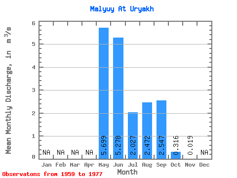
| Statistic | Jan | Feb | Mar | Apr | May | Jun | Jul | Aug | Sep | Oct | Nov | Dec | Annual |
|---|---|---|---|---|---|---|---|---|---|---|---|---|---|
| Mean | 5.70 | 5.28 | 2.03 | 2.47 | 2.55 | 0.32 | 0.02 | ||||||
| Standard Deviation | 3.22 | 2.28 | 1.10 | 1.47 | 1.81 | 0.27 | 0.03 | ||||||
| Min | 1.29 | 1.41 | 0.55 | 0.81 | 0.50 | 0.04 | 0.00 | ||||||
| Max | 13.00 | 9.00 | 4.39 | 6.97 | 5.80 | 1.26 | 0.05 | ||||||
| Coefficient of Variation | 0.56 | 0.43 | 0.54 | 0.60 | 0.71 | 0.85 | 1.42 |
 Return to R-Arctic Net Home Page