|
|
|||||||||||||||||
| Point ID: 588 | Downloads | Plots | Site Data | Code: 07AA009 |
|
|
|||||||||||||||||
| Download | |
|---|---|
| Site Descriptor Information | Site Time Series Data |
| Link to all available data | |
| View: | Time Series | All |
| Units: | mm |
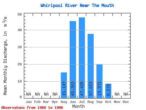
| Statistic | Jan | Feb | Mar | Apr | May | Jun | Jul | Aug | Sep | Oct | Nov | Dec | Annual |
|---|---|---|---|---|---|---|---|---|---|---|---|---|---|
| Mean | 15.15 | 45.30 | 47.44 | 37.65 | 19.97 | 8.57 | |||||||
| Standard Deviation | 5.61 | 9.46 | 8.65 | 6.35 | 6.00 | 2.08 | |||||||
| Min | 4.84 | 28.90 | 32.80 | 29.00 | 11.70 | 5.28 | |||||||
| Max | 25.90 | 63.00 | 64.30 | 56.80 | 40.00 | 13.30 | |||||||
| Coefficient of Variation | 0.37 | 0.21 | 0.18 | 0.17 | 0.30 | 0.24 |
 Return to R-Arctic Net Home Page