|
|
|||||||||||||||||
| Point ID: 5870 | Downloads | Plots | Site Data | Code: 1131 |
|
|
|||||||||||||||||
| Download | |
|---|---|
| Site Descriptor Information | Site Time Series Data |
| Link to all available data | |
| View: | Time Series | All |
| Units: | mm |
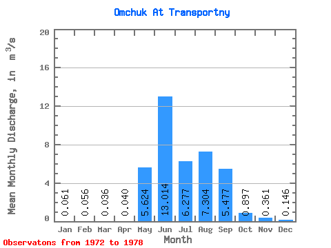
| Statistic | Jan | Feb | Mar | Apr | May | Jun | Jul | Aug | Sep | Oct | Nov | Dec | Annual |
|---|---|---|---|---|---|---|---|---|---|---|---|---|---|
| Mean | 0.06 | 0.06 | 0.04 | 0.04 | 5.62 | 13.01 | 6.28 | 7.30 | 5.48 | 0.90 | 0.36 | 0.15 | 4.01 |
| Standard Deviation | 0.07 | 0.03 | 0.04 | 0.03 | 4.29 | 8.26 | 3.36 | 5.23 | 4.19 | 0.30 | 0.19 | 0.10 | |
| Min | 0.01 | 0.03 | 0.01 | 0.00 | 1.75 | 3.60 | 2.40 | 1.98 | 1.17 | 0.42 | 0.18 | 0.02 | 4.01 |
| Max | 0.14 | 0.08 | 0.06 | 0.07 | 13.70 | 27.90 | 10.70 | 15.60 | 12.80 | 1.40 | 0.61 | 0.27 | 4.01 |
| Coefficient of Variation | 1.15 | 0.56 | 1.02 | 0.86 | 0.76 | 0.63 | 0.54 | 0.72 | 0.76 | 0.34 | 0.51 | 0.69 |
 Return to R-Arctic Net Home Page