|
|
|||||||||||||||||
| Point ID: 5858 | Downloads | Plots | Site Data | Code: 1010 |
|
|
|||||||||||||||||
| Download | |
|---|---|
| Site Descriptor Information | Site Time Series Data |
| Link to all available data | |
| View: | Time Series | All |
| Units: | mm |
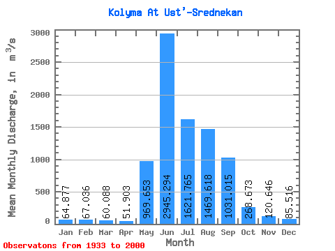
| Statistic | Jan | Feb | Mar | Apr | May | Jun | Jul | Aug | Sep | Oct | Nov | Dec | Annual |
|---|---|---|---|---|---|---|---|---|---|---|---|---|---|
| Mean | 64.88 | 67.04 | 60.09 | 51.90 | 969.65 | 2945.29 | 1621.77 | 1469.62 | 1031.02 | 268.67 | 120.65 | 85.52 | 728.21 |
| Standard Deviation | 99.22 | 116.39 | 112.15 | 99.94 | 599.68 | 1586.35 | 686.80 | 669.87 | 531.08 | 147.57 | 108.00 | 105.06 | 165.58 |
| Min | 7.95 | 4.16 | 2.56 | 2.46 | 33.20 | 1070.00 | 639.00 | 548.00 | 375.00 | 94.60 | 39.10 | 14.90 | 351.90 |
| Max | 387.00 | 403.00 | 408.00 | 387.00 | 3090.00 | 8140.00 | 4060.00 | 3800.00 | 2950.00 | 902.00 | 538.00 | 426.00 | 1092.68 |
| Coefficient of Variation | 1.53 | 1.74 | 1.87 | 1.93 | 0.62 | 0.54 | 0.42 | 0.46 | 0.52 | 0.55 | 0.90 | 1.23 | 0.23 |
 Return to R-Arctic Net Home Page