|
|
|||||||||||||||||
| Point ID: 5842 | Downloads | Plots | Site Data | Code: 10AA005 |
|
|
|||||||||||||||||
| Download | |
|---|---|
| Site Descriptor Information | Site Time Series Data |
| Link to all available data | |
| View: | Time Series | All |
| Units: | mm |
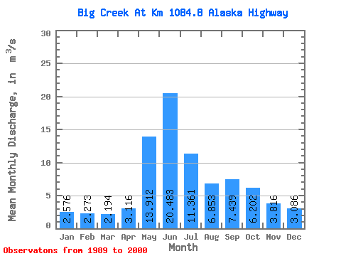
| Statistic | Jan | Feb | Mar | Apr | May | Jun | Jul | Aug | Sep | Oct | Nov | Dec | Annual |
|---|---|---|---|---|---|---|---|---|---|---|---|---|---|
| Mean | 2.58 | 2.27 | 2.19 | 3.12 | 13.91 | 20.48 | 11.36 | 6.85 | 7.44 | 6.20 | 3.82 | 3.09 | 6.89 |
| Standard Deviation | 0.85 | 0.72 | 0.61 | 0.62 | 3.44 | 8.87 | 3.29 | 1.52 | 2.62 | 1.68 | 1.07 | 0.93 | 0.97 |
| Min | 1.17 | 1.08 | 1.03 | 2.09 | 7.95 | 8.49 | 6.45 | 4.18 | 3.88 | 4.09 | 2.42 | 1.35 | 5.18 |
| Max | 4.11 | 3.73 | 3.20 | 4.13 | 20.80 | 38.00 | 18.00 | 9.02 | 13.40 | 9.61 | 6.48 | 4.96 | 8.89 |
| Coefficient of Variation | 0.33 | 0.32 | 0.28 | 0.20 | 0.25 | 0.43 | 0.29 | 0.22 | 0.35 | 0.27 | 0.28 | 0.30 | 0.14 |
 Return to R-Arctic Net Home Page