|
|
|||||||||||||||||
| Point ID: 5825 | Downloads | Plots | Site Data | Code: 09EA004 |
|
|
|||||||||||||||||
| Download | |
|---|---|
| Site Descriptor Information | Site Time Series Data |
| Link to all available data | |
| View: | Time Series | All |
| Units: | mm |
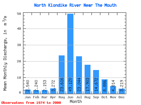
| Statistic | Jan | Feb | Mar | Apr | May | Jun | Jul | Aug | Sep | Oct | Nov | Dec | Annual |
|---|---|---|---|---|---|---|---|---|---|---|---|---|---|
| Mean | 2.54 | 2.24 | 2.15 | 3.27 | 23.62 | 49.12 | 23.04 | 17.90 | 14.67 | 8.89 | 4.81 | 3.22 | 13.07 |
| Standard Deviation | 0.36 | 0.32 | 0.31 | 1.66 | 8.94 | 15.30 | 8.72 | 5.98 | 4.71 | 2.69 | 1.34 | 0.77 | 2.71 |
| Min | 1.67 | 1.52 | 1.57 | 1.99 | 11.40 | 24.40 | 9.94 | 9.77 | 8.27 | 4.81 | 2.11 | 1.94 | 8.05 |
| Max | 3.11 | 2.74 | 2.94 | 10.00 | 46.80 | 87.80 | 46.50 | 30.00 | 25.90 | 15.70 | 8.38 | 5.44 | 18.60 |
| Coefficient of Variation | 0.14 | 0.14 | 0.14 | 0.51 | 0.38 | 0.31 | 0.38 | 0.33 | 0.32 | 0.30 | 0.28 | 0.24 | 0.21 |
 Return to R-Arctic Net Home Page