|
|
|||||||||||||||||
| Point ID: 5813 | Downloads | Plots | Site Data | Code: 09CA004 |
|
|
|||||||||||||||||
| Download | |
|---|---|
| Site Descriptor Information | Site Time Series Data |
| Link to all available data | |
| View: | Time Series | All |
| Units: | mm |
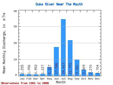
| Statistic | Jan | Feb | Mar | Apr | May | Jun | Jul | Aug | Sep | Oct | Nov | Dec | Annual |
|---|---|---|---|---|---|---|---|---|---|---|---|---|---|
| Mean | 1.25 | 1.06 | 0.95 | 1.23 | 5.33 | 17.59 | 34.42 | 21.79 | 9.76 | 3.81 | 2.27 | 1.70 | 8.32 |
| Standard Deviation | 0.37 | 0.36 | 0.36 | 0.32 | 2.50 | 11.69 | 24.68 | 8.12 | 9.24 | 0.71 | 0.34 | 0.40 | 2.96 |
| Min | 0.38 | 0.32 | 0.38 | 0.70 | 2.36 | 7.21 | 15.80 | 8.44 | 3.86 | 2.76 | 1.52 | 0.77 | 4.58 |
| Max | 1.93 | 1.59 | 1.43 | 1.90 | 13.80 | 49.90 | 109.00 | 37.40 | 45.20 | 5.36 | 2.72 | 2.60 | 16.39 |
| Coefficient of Variation | 0.29 | 0.34 | 0.38 | 0.26 | 0.47 | 0.66 | 0.72 | 0.37 | 0.95 | 0.19 | 0.15 | 0.23 | 0.35 |
 Return to R-Arctic Net Home Page