|
|
|||||||||||||||||
| Point ID: 5806 | Downloads | Plots | Site Data | Code: 09BC001 |
|
|
|||||||||||||||||
| Download | |
|---|---|
| Site Descriptor Information | Site Time Series Data |
| Link to all available data | |
| View: | Time Series | All |
| Units: | mm |
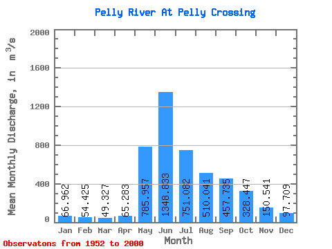
| Statistic | Jan | Feb | Mar | Apr | May | Jun | Jul | Aug | Sep | Oct | Nov | Dec | Annual |
|---|---|---|---|---|---|---|---|---|---|---|---|---|---|
| Mean | 66.96 | 54.42 | 49.33 | 65.28 | 785.96 | 1348.83 | 751.08 | 510.04 | 457.74 | 328.45 | 150.54 | 97.71 | 389.52 |
| Standard Deviation | 16.80 | 12.74 | 10.94 | 24.19 | 238.63 | 479.00 | 211.10 | 160.41 | 163.56 | 125.22 | 49.52 | 25.13 | 78.23 |
| Min | 36.80 | 32.60 | 28.90 | 36.30 | 391.00 | 536.00 | 346.00 | 244.00 | 175.00 | 121.00 | 58.60 | 54.10 | 259.85 |
| Max | 107.00 | 90.10 | 81.90 | 156.00 | 1630.00 | 2840.00 | 1290.00 | 905.00 | 930.00 | 847.00 | 352.00 | 181.00 | 574.06 |
| Coefficient of Variation | 0.25 | 0.23 | 0.22 | 0.37 | 0.30 | 0.35 | 0.28 | 0.32 | 0.36 | 0.38 | 0.33 | 0.26 | 0.20 |
 Return to R-Arctic Net Home Page