|
|
|||||||||||||||||
| Point ID: 5800 | Downloads | Plots | Site Data | Code: 09AH003 |
|
|
|||||||||||||||||
| Download | |
|---|---|
| Site Descriptor Information | Site Time Series Data |
| Link to all available data | |
| View: | Time Series | All |
| Units: | mm |
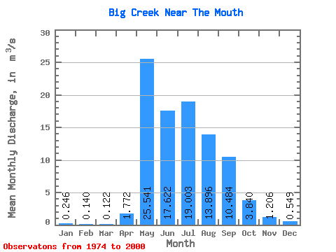
| Statistic | Jan | Feb | Mar | Apr | May | Jun | Jul | Aug | Sep | Oct | Nov | Dec | Annual |
|---|---|---|---|---|---|---|---|---|---|---|---|---|---|
| Mean | 0.25 | 0.14 | 0.12 | 1.77 | 25.54 | 17.62 | 19.00 | 13.90 | 10.48 | 3.84 | 1.21 | 0.55 | 7.98 |
| Standard Deviation | 0.25 | 0.11 | 0.11 | 4.56 | 18.25 | 8.90 | 10.70 | 8.27 | 7.74 | 2.34 | 0.94 | 0.61 | 3.50 |
| Min | 0.01 | 0.01 | 0.01 | 0.00 | 6.34 | 4.70 | 2.67 | 1.87 | 2.37 | 1.19 | 0.22 | 0.03 | 2.16 |
| Max | 1.10 | 0.45 | 0.49 | 21.80 | 76.80 | 38.80 | 42.50 | 32.60 | 37.00 | 12.80 | 4.09 | 2.42 | 17.11 |
| Coefficient of Variation | 1.01 | 0.78 | 0.92 | 2.58 | 0.71 | 0.51 | 0.56 | 0.59 | 0.74 | 0.61 | 0.78 | 1.11 | 0.44 |
 Return to R-Arctic Net Home Page