|
|
|||||||||||||||||
| Point ID: 5787 | Downloads | Plots | Site Data | Code: 09AB001 |
|
|
|||||||||||||||||
| Download | |
|---|---|
| Site Descriptor Information | Site Time Series Data |
| Link to all available data | |
| View: | Time Series | All |
| Units: | mm |
| Statistic | Jan | Feb | Mar | Apr | May | Jun | Jul | Aug | Sep | Oct | Nov | Dec | Annual |
|---|---|---|---|---|---|---|---|---|---|---|---|---|---|
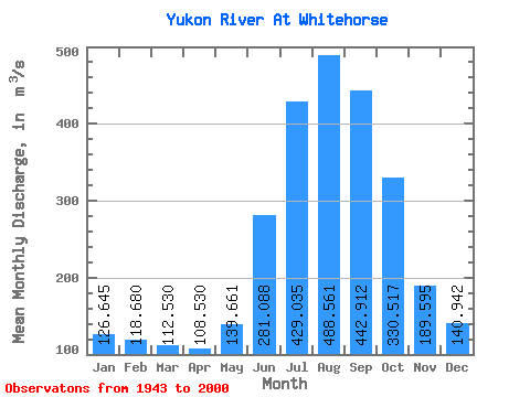
| Mean | 126.64 | 118.68 | 112.53 | 108.53 | 139.66 | 281.09 | 429.04 | 488.56 | 442.91 | 330.52 | 189.59 | 140.94 | 241.57 |
| Standard Deviation | 32.95 | 34.28 | 35.14 | 38.10 | 41.30 | 76.27 | 70.45 | 64.89 | 84.38 | 89.06 | 66.84 | 36.20 | 31.70 |
| Min | 56.60 | 55.60 | 56.40 | 49.60 | 68.20 | 149.00 | 287.00 | 352.00 | 236.00 | 162.00 | 76.50 | 58.90 | 185.15 |
| Max | 191.00 | 188.00 | 184.00 | 194.00 | 236.00 | 463.00 | 598.00 | 631.00 | 611.00 | 512.00 | 388.00 | 229.00 | 315.63 |
| Coefficient of Variation | 0.26 | 0.29 | 0.31 | 0.35 | 0.30 | 0.27 | 0.16 | 0.13 | 0.19 | 0.27 | 0.35 | 0.26 | 0.13 |
 Return to R-Arctic Net Home Page