|
|
|||||||||||||||||
| Point ID: 572 | Downloads | Plots | Site Data | Code: 06AB002 |
|
|
|||||||||||||||||
| Download | |
|---|---|
| Site Descriptor Information | Site Time Series Data |
| Link to all available data | |
| View: | Time Series | All |
| Units: | mm |
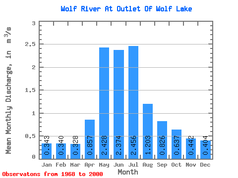
| Statistic | Jan | Feb | Mar | Apr | May | Jun | Jul | Aug | Sep | Oct | Nov | Dec | Annual |
|---|---|---|---|---|---|---|---|---|---|---|---|---|---|
| Mean | 0.34 | 0.34 | 0.33 | 0.86 | 2.43 | 2.37 | 2.46 | 1.20 | 0.83 | 0.64 | 0.44 | 0.40 | 1.02 |
| Standard Deviation | 0.36 | 0.30 | 0.27 | 1.04 | 3.59 | 3.50 | 3.75 | 1.59 | 1.14 | 0.99 | 0.69 | 0.49 | 0.97 |
| Min | 0.00 | 0.00 | 0.00 | 0.00 | 0.00 | 0.00 | 0.00 | 0.00 | 0.00 | 0.00 | 0.00 | 0.00 | 0.00 |
| Max | 1.41 | 1.03 | 0.86 | 4.74 | 18.70 | 17.10 | 13.20 | 6.83 | 4.30 | 3.65 | 2.68 | 1.95 | 3.31 |
| Coefficient of Variation | 1.06 | 0.89 | 0.81 | 1.21 | 1.48 | 1.47 | 1.53 | 1.33 | 1.38 | 1.55 | 1.57 | 1.22 | 0.95 |
 Return to R-Arctic Net Home Page