|
|
|||||||||||||||||
| Point ID: 57 | Downloads | Plots | Site Data | Code: 05AC003 |
|
|
|||||||||||||||||
| Download | |
|---|---|
| Site Descriptor Information | Site Time Series Data |
| Link to all available data | |
| View: | Time Series | All |
| Units: | mm |
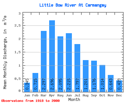
| Statistic | Jan | Feb | Mar | Apr | May | Jun | Jul | Aug | Sep | Oct | Nov | Dec | Annual |
|---|---|---|---|---|---|---|---|---|---|---|---|---|---|
| Mean | 0.34 | 0.71 | 2.30 | 2.70 | 2.10 | 2.21 | 1.80 | 1.20 | 1.18 | 1.01 | 0.64 | 0.44 | 1.43 |
| Standard Deviation | 0.29 | 0.63 | 2.37 | 3.26 | 1.69 | 1.81 | 1.70 | 0.72 | 0.86 | 0.68 | 0.28 | 0.29 | 0.66 |
| Min | 0.00 | 0.00 | 0.00 | 0.28 | 0.41 | 0.23 | 0.04 | 0.04 | 0.06 | 0.11 | 0.09 | 0.01 | 0.38 |
| Max | 1.07 | 2.51 | 10.90 | 21.40 | 10.80 | 8.59 | 9.85 | 3.35 | 4.74 | 4.12 | 1.36 | 1.47 | 2.87 |
| Coefficient of Variation | 0.85 | 0.89 | 1.03 | 1.21 | 0.81 | 0.81 | 0.95 | 0.60 | 0.73 | 0.68 | 0.43 | 0.67 | 0.46 |
 Return to R-Arctic Net Home Page