|
|
|||||||||||||||||
| Point ID: 567 | Downloads | Plots | Site Data | Code: 06AA001 |
|
|
|||||||||||||||||
| Download | |
|---|---|
| Site Descriptor Information | Site Time Series Data |
| Link to all available data | |
| View: | Time Series | All |
| Units: | mm |
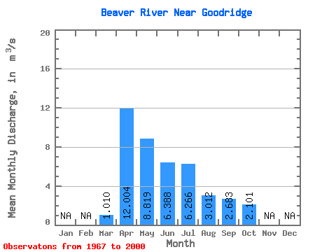
| Statistic | Jan | Feb | Mar | Apr | May | Jun | Jul | Aug | Sep | Oct | Nov | Dec | Annual |
|---|---|---|---|---|---|---|---|---|---|---|---|---|---|
| Mean | 1.01 | 12.00 | 8.82 | 6.39 | 6.27 | 3.01 | 2.68 | 2.10 | |||||
| Standard Deviation | 1.09 | 14.27 | 12.38 | 9.19 | 10.87 | 4.56 | 4.58 | 3.24 | |||||
| Min | 0.00 | 0.01 | 0.02 | 0.01 | 0.00 | 0.00 | 0.00 | 0.00 | |||||
| Max | 4.34 | 54.90 | 51.90 | 37.60 | 44.50 | 21.10 | 18.70 | 12.80 | |||||
| Coefficient of Variation | 1.08 | 1.19 | 1.40 | 1.44 | 1.73 | 1.51 | 1.71 | 1.54 |
 Return to R-Arctic Net Home Page