|
|
|||||||||||||||||
| Point ID: 5621 | Downloads | Plots | Site Data | Code: 07MB001 |
|
|
|||||||||||||||||
| Download | |
|---|---|
| Site Descriptor Information | Site Time Series Data |
| Link to all available data | |
| View: | Time Series | All |
| Units: | mm |
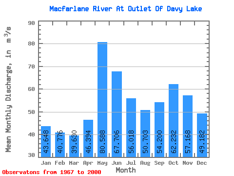
| Statistic | Jan | Feb | Mar | Apr | May | Jun | Jul | Aug | Sep | Oct | Nov | Dec | Annual |
|---|---|---|---|---|---|---|---|---|---|---|---|---|---|
| Mean | 43.65 | 40.78 | 39.63 | 46.39 | 80.59 | 67.71 | 56.02 | 50.70 | 54.20 | 62.23 | 57.17 | 49.18 | 53.87 |
| Standard Deviation | 8.76 | 7.85 | 6.78 | 10.67 | 15.03 | 14.38 | 13.60 | 13.83 | 14.80 | 23.63 | 16.28 | 10.65 | 9.07 |
| Min | 27.50 | 22.80 | 21.60 | 23.70 | 45.90 | 40.20 | 34.30 | 30.70 | 26.80 | 27.00 | 32.20 | 32.80 | 36.16 |
| Max | 72.00 | 66.00 | 61.50 | 83.30 | 111.00 | 106.00 | 96.40 | 83.10 | 97.60 | 163.00 | 119.00 | 87.20 | 81.32 |
| Coefficient of Variation | 0.20 | 0.19 | 0.17 | 0.23 | 0.19 | 0.21 | 0.24 | 0.27 | 0.27 | 0.38 | 0.28 | 0.22 | 0.17 |
 Return to R-Arctic Net Home Page