|
|
|||||||||||||||||
| Point ID: 5611 | Downloads | Plots | Site Data | Code: 07LC003 |
|
|
|||||||||||||||||
| Download | |
|---|---|
| Site Descriptor Information | Site Time Series Data |
| Link to all available data | |
| View: | Time Series | All |
| Units: | mm |
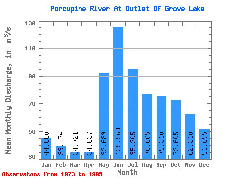
| Statistic | Jan | Feb | Mar | Apr | May | Jun | Jul | Aug | Sep | Oct | Nov | Dec | Annual |
|---|---|---|---|---|---|---|---|---|---|---|---|---|---|
| Mean | 44.88 | 39.17 | 34.72 | 34.84 | 92.69 | 125.56 | 95.20 | 76.61 | 75.31 | 72.61 | 62.31 | 51.70 | 69.24 |
| Standard Deviation | 11.45 | 9.98 | 8.35 | 8.21 | 31.03 | 34.91 | 33.53 | 27.40 | 29.43 | 28.29 | 22.71 | 16.52 | 16.17 |
| Min | 22.80 | 19.00 | 16.90 | 22.00 | 46.30 | 64.80 | 37.10 | 47.10 | 35.30 | 34.20 | 21.40 | 18.10 | 44.42 |
| Max | 63.70 | 55.70 | 49.40 | 54.50 | 135.00 | 194.00 | 199.00 | 165.00 | 159.00 | 147.00 | 117.00 | 85.00 | 107.92 |
| Coefficient of Variation | 0.26 | 0.26 | 0.24 | 0.24 | 0.34 | 0.28 | 0.35 | 0.36 | 0.39 | 0.39 | 0.36 | 0.32 | 0.23 |
 Return to R-Arctic Net Home Page