|
|
|||||||||||||||||
| Point ID: 5589 | Downloads | Plots | Site Data | Code: 06CB002 |
|
|
|||||||||||||||||
| Download | |
|---|---|
| Site Descriptor Information | Site Time Series Data |
| Link to all available data | |
| View: | Time Series | All |
| Units: | mm |
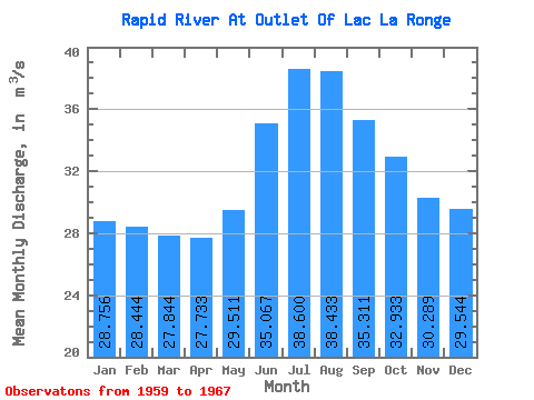
| Statistic | Jan | Feb | Mar | Apr | May | Jun | Jul | Aug | Sep | Oct | Nov | Dec | Annual |
|---|---|---|---|---|---|---|---|---|---|---|---|---|---|
| Mean | 28.76 | 28.44 | 27.84 | 27.73 | 29.51 | 35.07 | 38.60 | 38.43 | 35.31 | 32.93 | 30.29 | 29.54 | 31.87 |
| Standard Deviation | 5.80 | 5.70 | 5.53 | 5.34 | 5.34 | 6.87 | 7.31 | 8.21 | 7.64 | 7.01 | 5.95 | 6.19 | 5.31 |
| Min | 19.30 | 19.10 | 18.70 | 18.60 | 19.10 | 22.30 | 26.10 | 23.90 | 24.30 | 22.30 | 20.30 | 19.40 | 24.71 |
| Max | 37.10 | 36.70 | 35.40 | 34.40 | 36.00 | 44.30 | 49.30 | 47.50 | 44.90 | 41.30 | 36.40 | 36.30 | 38.68 |
| Coefficient of Variation | 0.20 | 0.20 | 0.20 | 0.19 | 0.18 | 0.20 | 0.19 | 0.21 | 0.22 | 0.21 | 0.20 | 0.21 | 0.17 |
 Return to R-Arctic Net Home Page