|
|
|||||||||||||||||
| Point ID: 5572 | Downloads | Plots | Site Data | Code: 06AD011 |
|
|
|||||||||||||||||
| Download | |
|---|---|
| Site Descriptor Information | Site Time Series Data |
| Link to all available data | |
| View: | Time Series | All |
| Units: | mm |
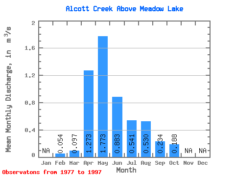
| Statistic | Jan | Feb | Mar | Apr | May | Jun | Jul | Aug | Sep | Oct | Nov | Dec | Annual |
|---|---|---|---|---|---|---|---|---|---|---|---|---|---|
| Mean | 0.05 | 0.10 | 1.27 | 1.77 | 0.88 | 0.54 | 0.53 | 0.23 | 0.19 | ||||
| Standard Deviation | 0.08 | 1.01 | 1.59 | 1.03 | 0.65 | 1.29 | 0.38 | 0.17 | |||||
| Min | 0.05 | 0.02 | 0.18 | 0.09 | 0.04 | 0.00 | 0.01 | 0.00 | 0.02 | ||||
| Max | 0.05 | 0.34 | 4.55 | 5.50 | 4.20 | 2.10 | 5.76 | 1.22 | 0.66 | ||||
| Coefficient of Variation | 0.81 | 0.80 | 0.90 | 1.17 | 1.21 | 2.44 | 1.63 | 0.92 |
 Return to R-Arctic Net Home Page