|
|
|||||||||||||||||
| Point ID: 5570 | Downloads | Plots | Site Data | Code: 06AD009 |
|
|
|||||||||||||||||
| Download | |
|---|---|
| Site Descriptor Information | Site Time Series Data |
| Link to all available data | |
| View: | Time Series | All |
| Units: | mm |
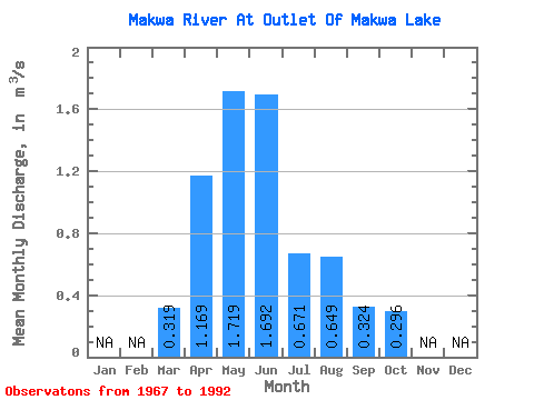
| Statistic | Jan | Feb | Mar | Apr | May | Jun | Jul | Aug | Sep | Oct | Nov | Dec | Annual |
|---|---|---|---|---|---|---|---|---|---|---|---|---|---|
| Mean | 0.32 | 1.17 | 1.72 | 1.69 | 0.67 | 0.65 | 0.32 | 0.30 | |||||
| Standard Deviation | 0.33 | 1.10 | 2.41 | 3.60 | 0.93 | 1.38 | 0.63 | 0.78 | |||||
| Min | 0.00 | 0.00 | 0.00 | 0.00 | 0.00 | 0.00 | 0.00 | 0.00 | |||||
| Max | 1.01 | 3.94 | 11.40 | 16.10 | 3.70 | 5.41 | 2.21 | 3.33 | |||||
| Coefficient of Variation | 1.03 | 0.94 | 1.40 | 2.13 | 1.38 | 2.13 | 1.95 | 2.65 |
 Return to R-Arctic Net Home Page