|
|
|||||||||||||||||
| Point ID: 5569 | Downloads | Plots | Site Data | Code: 06AD008 |
|
|
|||||||||||||||||
| Download | |
|---|---|
| Site Descriptor Information | Site Time Series Data |
| Link to all available data | |
| View: | Time Series | All |
| Units: | mm |
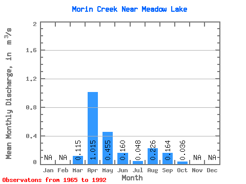
| Statistic | Jan | Feb | Mar | Apr | May | Jun | Jul | Aug | Sep | Oct | Nov | Dec | Annual |
|---|---|---|---|---|---|---|---|---|---|---|---|---|---|
| Mean | 0.12 | 1.01 | 0.46 | 0.16 | 0.05 | 0.23 | 0.16 | 0.04 | |||||
| Standard Deviation | 0.24 | 0.71 | 0.61 | 0.37 | 0.09 | 0.64 | 0.61 | 0.10 | |||||
| Min | 0.00 | 0.01 | 0.00 | 0.00 | 0.00 | 0.00 | 0.00 | 0.00 | |||||
| Max | 0.72 | 2.60 | 2.01 | 1.53 | 0.29 | 2.20 | 2.51 | 0.38 | |||||
| Coefficient of Variation | 2.08 | 0.70 | 1.33 | 2.31 | 1.81 | 2.83 | 3.69 | 2.62 |
 Return to R-Arctic Net Home Page