|
|
|||||||||||||||||
| Point ID: 5562 | Downloads | Plots | Site Data | Code: 05NF013 |
|
|
|||||||||||||||||
| Download | |
|---|---|
| Site Descriptor Information | Site Time Series Data |
| Link to all available data | |
| View: | Time Series | All |
| Units: | mm |
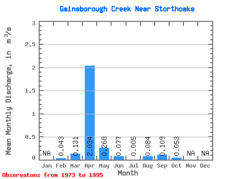
| Statistic | Jan | Feb | Mar | Apr | May | Jun | Jul | Aug | Sep | Oct | Nov | Dec | Annual |
|---|---|---|---|---|---|---|---|---|---|---|---|---|---|
| Mean | 0.04 | 0.13 | 2.03 | 0.27 | 0.08 | 0.01 | 0.08 | 0.11 | 0.05 | ||||
| Standard Deviation | 0.04 | 0.35 | 4.77 | 0.52 | 0.29 | 0.01 | 0.40 | 0.39 | 0.19 | ||||
| Min | 0.01 | 0.00 | 0.00 | 0.00 | 0.00 | 0.00 | 0.00 | 0.00 | 0.00 | ||||
| Max | 0.07 | 1.63 | 22.40 | 2.13 | 1.39 | 0.06 | 1.92 | 1.74 | 0.84 | ||||
| Coefficient of Variation | 0.96 | 2.69 | 2.34 | 1.94 | 3.76 | 2.95 | 4.79 | 3.58 | 3.55 |
 Return to R-Arctic Net Home Page