|
|
|||||||||||||||||
| Point ID: 556 | Downloads | Plots | Site Data | Code: 05FE002 |
|
|
|||||||||||||||||
| Download | |
|---|---|
| Site Descriptor Information | Site Time Series Data |
| Link to all available data | |
| View: | Time Series | All |
| Units: | mm |
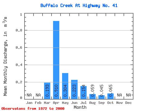
| Statistic | Jan | Feb | Mar | Apr | May | Jun | Jul | Aug | Sep | Oct | Nov | Dec | Annual |
|---|---|---|---|---|---|---|---|---|---|---|---|---|---|
| Mean | 0.19 | 0.91 | 0.30 | 0.22 | 0.15 | 0.06 | 0.04 | 0.07 | |||||
| Standard Deviation | 0.20 | 1.13 | 0.20 | 0.18 | 0.16 | 0.08 | 0.04 | 0.03 | |||||
| Min | 0.00 | 0.31 | 0.13 | 0.02 | 0.00 | 0.00 | 0.00 | 0.01 | |||||
| Max | 0.70 | 6.33 | 0.98 | 0.66 | 0.61 | 0.42 | 0.14 | 0.13 | |||||
| Coefficient of Variation | 1.01 | 1.24 | 0.64 | 0.79 | 1.04 | 1.40 | 0.89 | 0.48 |
 Return to R-Arctic Net Home Page