|
|
|||||||||||||||||
| Point ID: 5555 | Downloads | Plots | Site Data | Code: 05ND007 |
|
|
|||||||||||||||||
| Download | |
|---|---|
| Site Descriptor Information | Site Time Series Data |
| Link to all available data | |
| View: | Time Series | All |
| Units: | mm |
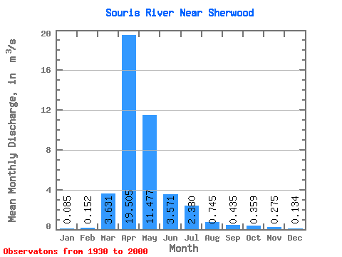
| Statistic | Jan | Feb | Mar | Apr | May | Jun | Jul | Aug | Sep | Oct | Nov | Dec | Annual |
|---|---|---|---|---|---|---|---|---|---|---|---|---|---|
| Mean | 0.09 | 0.15 | 3.63 | 19.50 | 11.48 | 3.57 | 2.38 | 0.74 | 0.43 | 0.36 | 0.28 | 0.13 | 3.59 |
| Standard Deviation | 0.16 | 0.51 | 5.41 | 30.03 | 21.73 | 5.57 | 4.56 | 1.36 | 0.86 | 0.63 | 0.36 | 0.19 | 4.48 |
| Min | 0.00 | 0.00 | 0.00 | 0.05 | 0.07 | 0.01 | 0.00 | 0.00 | 0.00 | 0.00 | 0.00 | 0.00 | 0.01 |
| Max | 1.26 | 4.05 | 32.50 | 191.00 | 113.00 | 27.00 | 29.70 | 9.18 | 4.91 | 3.41 | 1.85 | 1.35 | 24.76 |
| Coefficient of Variation | 1.85 | 3.33 | 1.49 | 1.54 | 1.89 | 1.56 | 1.92 | 1.82 | 1.97 | 1.77 | 1.31 | 1.44 | 1.25 |
 Return to R-Arctic Net Home Page