|
|
|||||||||||||||||
| Point ID: 5552 | Downloads | Plots | Site Data | Code: 05ND001 |
|
|
|||||||||||||||||
| Download | |
|---|---|
| Site Descriptor Information | Site Time Series Data |
| Link to all available data | |
| View: | Time Series | All |
| Units: | mm |
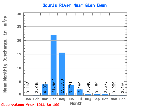
| Statistic | Jan | Feb | Mar | Apr | May | Jun | Jul | Aug | Sep | Oct | Nov | Dec | Annual |
|---|---|---|---|---|---|---|---|---|---|---|---|---|---|
| Mean | 0.10 | 0.25 | 4.05 | 21.97 | 15.55 | 3.72 | 2.15 | 0.64 | 0.48 | 0.58 | 0.29 | 0.15 | 4.37 |
| Standard Deviation | 0.21 | 0.54 | 7.29 | 39.26 | 27.41 | 6.12 | 3.69 | 0.85 | 0.83 | 0.84 | 0.36 | 0.24 | 6.29 |
| Min | 0.00 | 0.00 | 0.01 | 0.05 | 0.06 | 0.00 | 0.00 | 0.00 | 0.00 | 0.00 | 0.00 | 0.00 | 0.01 |
| Max | 1.07 | 2.43 | 32.10 | 191.00 | 111.00 | 27.50 | 16.60 | 3.06 | 3.54 | 3.39 | 1.41 | 1.21 | 24.77 |
| Coefficient of Variation | 2.06 | 2.21 | 1.80 | 1.79 | 1.76 | 1.64 | 1.71 | 1.33 | 1.72 | 1.46 | 1.26 | 1.59 | 1.44 |
 Return to R-Arctic Net Home Page