|
|
|||||||||||||||||
| Point ID: 5549 | Downloads | Plots | Site Data | Code: 05NC003 |
|
|
|||||||||||||||||
| Download | |
|---|---|
| Site Descriptor Information | Site Time Series Data |
| Link to all available data | |
| View: | Time Series | All |
| Units: | mm |
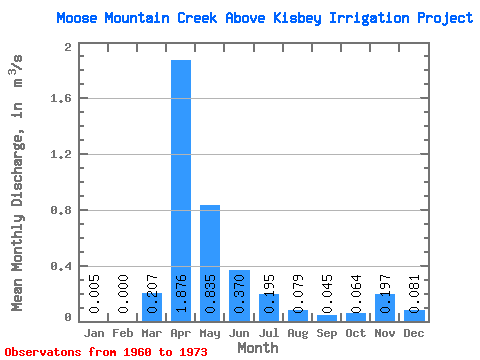
| Statistic | Jan | Feb | Mar | Apr | May | Jun | Jul | Aug | Sep | Oct | Nov | Dec | Annual |
|---|---|---|---|---|---|---|---|---|---|---|---|---|---|
| Mean | 0.01 | 0.00 | 0.21 | 1.88 | 0.83 | 0.37 | 0.20 | 0.08 | 0.04 | 0.06 | 0.20 | 0.08 | 0.64 |
| Standard Deviation | 0.01 | 0.00 | 0.46 | 2.63 | 1.17 | 0.46 | 0.25 | 0.16 | 0.10 | 0.10 | 0.16 | 0.06 | 0.24 |
| Min | 0.00 | 0.00 | 0.00 | 0.11 | 0.11 | 0.05 | 0.00 | 0.00 | 0.00 | 0.00 | 0.08 | 0.02 | 0.47 |
| Max | 0.01 | 0.00 | 1.74 | 8.67 | 4.19 | 1.83 | 0.78 | 0.59 | 0.40 | 0.36 | 0.38 | 0.15 | 0.81 |
| Coefficient of Variation | 1.41 | 2.25 | 1.40 | 1.40 | 1.23 | 1.30 | 1.99 | 2.30 | 1.50 | 0.80 | 0.79 | 0.37 |
 Return to R-Arctic Net Home Page