|
|
|||||||||||||||||
| Point ID: 553 | Downloads | Plots | Site Data | Code: 05FD003 |
|
|
|||||||||||||||||
| Download | |
|---|---|
| Site Descriptor Information | Site Time Series Data |
| Link to all available data | |
| View: | Time Series | All |
| Units: | mm |
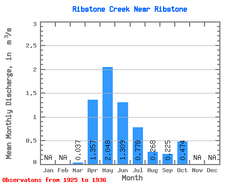
| Statistic | Jan | Feb | Mar | Apr | May | Jun | Jul | Aug | Sep | Oct | Nov | Dec | Annual |
|---|---|---|---|---|---|---|---|---|---|---|---|---|---|
| Mean | 0.04 | 1.36 | 2.05 | 1.31 | 0.78 | 0.27 | 0.23 | 0.47 | |||||
| Standard Deviation | 0.04 | 0.66 | 1.68 | 1.09 | 0.96 | 0.47 | 0.39 | 0.63 | |||||
| Min | 0.00 | 0.74 | 0.61 | 0.39 | 0.08 | 0.00 | 0.00 | 0.00 | |||||
| Max | 0.10 | 2.58 | 4.88 | 3.20 | 2.60 | 1.20 | 1.06 | 1.65 | |||||
| Coefficient of Variation | 1.22 | 0.49 | 0.82 | 0.83 | 1.23 | 1.75 | 1.74 | 1.32 |
 Return to R-Arctic Net Home Page