|
|
|||||||||||||||||
| Point ID: 552 | Downloads | Plots | Site Data | Code: 05FD001 |
|
|
|||||||||||||||||
| Download | |
|---|---|
| Site Descriptor Information | Site Time Series Data |
| Link to all available data | |
| View: | Time Series | All |
| Units: | mm |
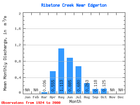
| Statistic | Jan | Feb | Mar | Apr | May | Jun | Jul | Aug | Sep | Oct | Nov | Dec | Annual |
|---|---|---|---|---|---|---|---|---|---|---|---|---|---|
| Mean | 0.04 | 0.56 | 1.11 | 0.89 | 0.68 | 0.26 | 0.12 | 0.12 | |||||
| Standard Deviation | 0.08 | 0.76 | 1.50 | 0.85 | 0.77 | 0.34 | 0.17 | 0.21 | |||||
| Min | 0.00 | 0.00 | 0.00 | 0.00 | 0.00 | 0.00 | 0.00 | 0.00 | |||||
| Max | 0.40 | 3.54 | 7.19 | 4.71 | 3.47 | 1.69 | 0.97 | 1.19 | |||||
| Coefficient of Variation | 2.19 | 1.36 | 1.35 | 0.96 | 1.14 | 1.30 | 1.42 | 1.68 |
 Return to R-Arctic Net Home Page