|
|
|||||||||||||||||
| Point ID: 5518 | Downloads | Plots | Site Data | Code: 05NA003 |
|
|
|||||||||||||||||
| Download | |
|---|---|
| Site Descriptor Information | Site Time Series Data |
| Link to all available data | |
| View: | Time Series | All |
| Units: | mm |
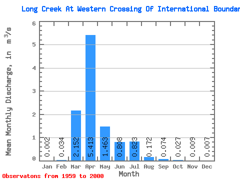
| Statistic | Jan | Feb | Mar | Apr | May | Jun | Jul | Aug | Sep | Oct | Nov | Dec | Annual |
|---|---|---|---|---|---|---|---|---|---|---|---|---|---|
| Mean | 0.00 | 0.03 | 2.15 | 5.41 | 1.46 | 0.81 | 0.82 | 0.17 | 0.07 | 0.03 | 0.01 | 0.01 | 0.92 |
| Standard Deviation | 0.01 | 0.13 | 4.00 | 8.27 | 3.36 | 1.94 | 2.14 | 0.53 | 0.28 | 0.11 | 0.03 | 0.02 | 1.05 |
| Min | 0.00 | 0.00 | 0.00 | 0.00 | 0.00 | 0.00 | 0.00 | 0.00 | 0.00 | 0.00 | 0.00 | 0.00 | 0.00 |
| Max | 0.05 | 0.75 | 15.40 | 29.80 | 16.40 | 10.20 | 11.70 | 3.25 | 1.74 | 0.71 | 0.12 | 0.08 | 4.28 |
| Coefficient of Variation | 3.97 | 3.85 | 1.86 | 1.53 | 2.29 | 2.41 | 2.60 | 3.08 | 3.75 | 4.22 | 2.76 | 2.67 | 1.15 |
 Return to R-Arctic Net Home Page