|
|
|||||||||||||||||
| Point ID: 5515 | Downloads | Plots | Site Data | Code: 05ME007 |
|
|
|||||||||||||||||
| Download | |
|---|---|
| Site Descriptor Information | Site Time Series Data |
| Link to all available data | |
| View: | Time Series | All |
| Units: | mm |
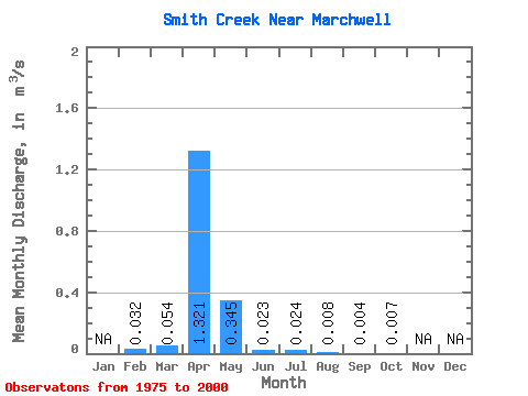
| Statistic | Jan | Feb | Mar | Apr | May | Jun | Jul | Aug | Sep | Oct | Nov | Dec | Annual |
|---|---|---|---|---|---|---|---|---|---|---|---|---|---|
| Mean | 0.03 | 0.05 | 1.32 | 0.34 | 0.02 | 0.02 | 0.01 | 0.00 | 0.01 | ||||
| Standard Deviation | 0.13 | 1.55 | 0.70 | 0.04 | 0.05 | 0.01 | 0.01 | 0.01 | |||||
| Min | 0.03 | 0.00 | 0.00 | 0.00 | 0.00 | 0.00 | 0.00 | 0.00 | 0.00 | ||||
| Max | 0.03 | 0.52 | 7.15 | 3.36 | 0.16 | 0.19 | 0.07 | 0.04 | 0.04 | ||||
| Coefficient of Variation | 2.41 | 1.18 | 2.03 | 1.68 | 1.96 | 1.93 | 2.15 | 1.83 |
 Return to R-Arctic Net Home Page