|
|
|||||||||||||||||
| Point ID: 5513 | Downloads | Plots | Site Data | Code: 05MD006 |
|
|
|||||||||||||||||
| Download | |
|---|---|
| Site Descriptor Information | Site Time Series Data |
| Link to all available data | |
| View: | Time Series | All |
| Units: | mm |
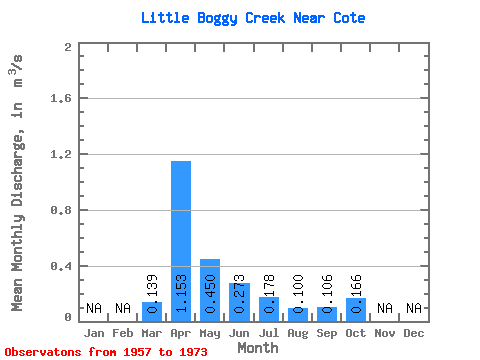
| Statistic | Jan | Feb | Mar | Apr | May | Jun | Jul | Aug | Sep | Oct | Nov | Dec | Annual |
|---|---|---|---|---|---|---|---|---|---|---|---|---|---|
| Mean | 0.14 | 1.15 | 0.45 | 0.27 | 0.18 | 0.10 | 0.11 | 0.17 | |||||
| Standard Deviation | 0.26 | 0.74 | 0.25 | 0.21 | 0.12 | 0.06 | 0.08 | 0.11 | |||||
| Min | 0.00 | 0.25 | 0.23 | 0.06 | 0.05 | 0.01 | 0.00 | 0.03 | |||||
| Max | 0.92 | 2.48 | 1.25 | 0.72 | 0.55 | 0.24 | 0.33 | 0.43 | |||||
| Coefficient of Variation | 1.87 | 0.64 | 0.56 | 0.76 | 0.65 | 0.62 | 0.77 | 0.68 |
 Return to R-Arctic Net Home Page