|
|
|||||||||||||||||
| Point ID: 5505 | Downloads | Plots | Site Data | Code: 05MB008 |
|
|
|||||||||||||||||
| Download | |
|---|---|
| Site Descriptor Information | Site Time Series Data |
| Link to all available data | |
| View: | Time Series | All |
| Units: | mm |
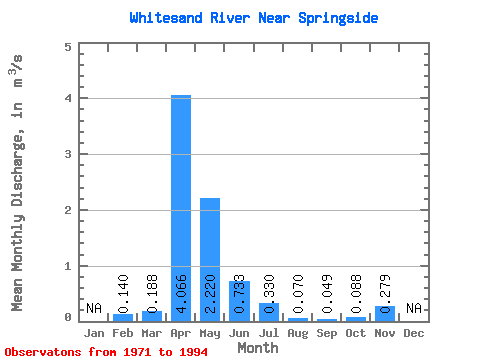
| Statistic | Jan | Feb | Mar | Apr | May | Jun | Jul | Aug | Sep | Oct | Nov | Dec | Annual |
|---|---|---|---|---|---|---|---|---|---|---|---|---|---|
| Mean | 0.14 | 0.19 | 4.07 | 2.22 | 0.73 | 0.33 | 0.07 | 0.05 | 0.09 | 0.28 | |||
| Standard Deviation | 0.33 | 4.42 | 3.21 | 1.13 | 0.54 | 0.14 | 0.10 | 0.12 | 0.01 | ||||
| Min | 0.14 | 0.00 | 0.04 | 0.03 | 0.00 | 0.00 | 0.00 | 0.00 | 0.00 | 0.27 | |||
| Max | 0.14 | 1.23 | 16.40 | 10.60 | 4.92 | 2.11 | 0.66 | 0.46 | 0.56 | 0.29 | |||
| Coefficient of Variation | 1.73 | 1.09 | 1.45 | 1.54 | 1.65 | 1.99 | 1.97 | 1.31 | 0.05 |
 Return to R-Arctic Net Home Page