|
|
|||||||||||||||||
| Point ID: 5504 | Downloads | Plots | Site Data | Code: 05MB007 |
|
|
|||||||||||||||||
| Download | |
|---|---|
| Site Descriptor Information | Site Time Series Data |
| Link to all available data | |
| View: | Time Series | All |
| Units: | mm |
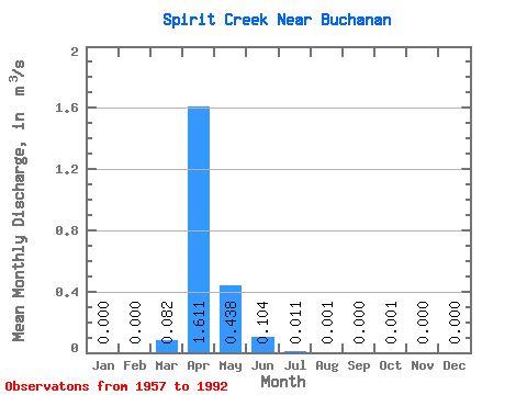
| Statistic | Jan | Feb | Mar | Apr | May | Jun | Jul | Aug | Sep | Oct | Nov | Dec | Annual |
|---|---|---|---|---|---|---|---|---|---|---|---|---|---|
| Mean | 0.00 | 0.00 | 0.08 | 1.61 | 0.44 | 0.10 | 0.01 | 0.00 | 0.00 | 0.00 | 0.00 | 0.00 | 0.14 |
| Standard Deviation | 0.00 | 0.00 | 0.20 | 1.45 | 1.06 | 0.38 | 0.03 | 0.01 | 0.00 | 0.00 | 0.00 | 0.00 | 0.07 |
| Min | 0.00 | 0.00 | 0.00 | 0.00 | 0.00 | 0.00 | 0.00 | 0.00 | 0.00 | 0.00 | 0.00 | 0.00 | 0.08 |
| Max | 0.00 | 0.00 | 0.85 | 4.72 | 5.53 | 2.05 | 0.15 | 0.02 | 0.00 | 0.01 | 0.00 | 0.00 | 0.22 |
| Coefficient of Variation | 2.42 | 0.90 | 2.42 | 3.65 | 2.59 | 3.14 | 3.43 | 3.57 | 0.53 |
 Return to R-Arctic Net Home Page