|
|
|||||||||||||||||
| Point ID: 55 | Downloads | Plots | Site Data | Code: 05AC001 |
|
|
|||||||||||||||||
| Download | |
|---|---|
| Site Descriptor Information | Site Time Series Data |
| Link to all available data | |
| View: | Time Series | All |
| Units: | mm |
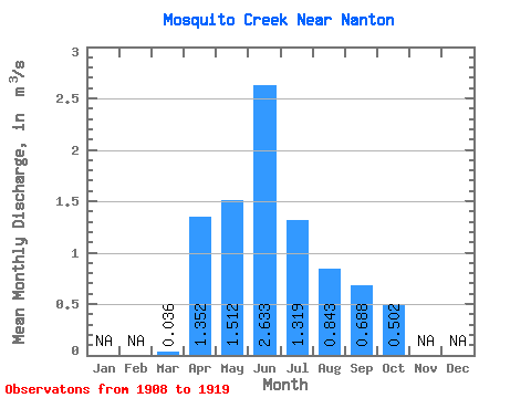
| Statistic | Jan | Feb | Mar | Apr | May | Jun | Jul | Aug | Sep | Oct | Nov | Dec | Annual |
|---|---|---|---|---|---|---|---|---|---|---|---|---|---|
| Mean | 0.04 | 1.35 | 1.51 | 2.63 | 1.32 | 0.84 | 0.69 | 0.50 | |||||
| Standard Deviation | 1.41 | 1.79 | 3.94 | 1.94 | 0.98 | 1.21 | 0.71 | ||||||
| Min | 0.04 | 0.15 | 0.13 | 0.01 | 0.00 | 0.00 | 0.00 | 0.01 | |||||
| Max | 0.04 | 4.35 | 4.86 | 10.80 | 6.46 | 2.96 | 4.31 | 2.54 | |||||
| Coefficient of Variation | 1.04 | 1.18 | 1.50 | 1.47 | 1.16 | 1.75 | 1.41 |
 Return to R-Arctic Net Home Page