|
|
|||||||||||||||||
| Point ID: 546 | Downloads | Plots | Site Data | Code: 05FC003 |
|
|
|||||||||||||||||
| Download | |
|---|---|
| Site Descriptor Information | Site Time Series Data |
| Link to all available data | |
| View: | Time Series | All |
| Units: | mm |
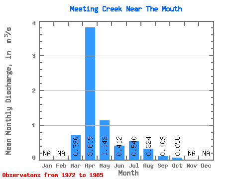
| Statistic | Jan | Feb | Mar | Apr | May | Jun | Jul | Aug | Sep | Oct | Nov | Dec | Annual |
|---|---|---|---|---|---|---|---|---|---|---|---|---|---|
| Mean | 0.73 | 3.82 | 1.14 | 0.41 | 0.54 | 0.32 | 0.10 | 0.06 | |||||
| Standard Deviation | 1.14 | 7.77 | 2.72 | 0.55 | 0.92 | 0.88 | 0.23 | 0.07 | |||||
| Min | 0.00 | 0.04 | 0.02 | 0.01 | 0.00 | 0.00 | 0.00 | 0.00 | |||||
| Max | 3.92 | 30.40 | 10.10 | 1.62 | 3.27 | 3.36 | 0.84 | 0.18 | |||||
| Coefficient of Variation | 1.56 | 2.03 | 2.38 | 1.34 | 1.71 | 2.72 | 2.24 | 1.22 |
 Return to R-Arctic Net Home Page