|
|
|||||||||||||||||
| Point ID: 5458 | Downloads | Plots | Site Data | Code: 05KH012 |
|
|
|||||||||||||||||
| Download | |
|---|---|
| Site Descriptor Information | Site Time Series Data |
| Link to all available data | |
| View: | Time Series | All |
| Units: | mm |
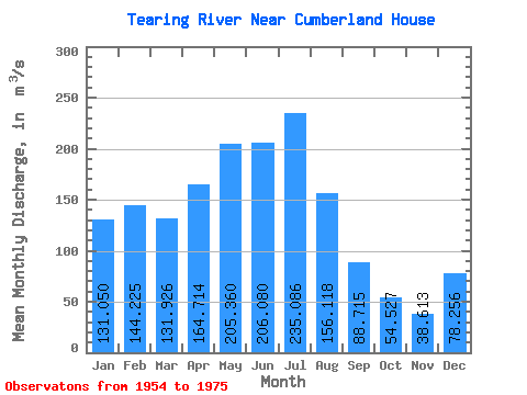
| Statistic | Jan | Feb | Mar | Apr | May | Jun | Jul | Aug | Sep | Oct | Nov | Dec | Annual |
|---|---|---|---|---|---|---|---|---|---|---|---|---|---|
| Mean | 131.05 | 144.22 | 131.93 | 164.71 | 205.36 | 206.08 | 235.09 | 156.12 | 88.72 | 54.53 | 38.61 | 78.26 | 124.42 |
| Standard Deviation | 48.91 | 44.16 | 46.77 | 53.01 | 146.58 | 110.43 | 119.26 | 93.06 | 122.28 | 78.65 | 27.74 | 40.94 | 41.30 |
| Min | 56.80 | 79.60 | 6.29 | 108.00 | 41.40 | 29.10 | 50.80 | 56.80 | 18.40 | 1.21 | 1.03 | 6.98 | 64.47 |
| Max | 211.00 | 219.00 | 197.00 | 275.00 | 683.00 | 469.00 | 589.00 | 446.00 | 590.00 | 330.00 | 93.10 | 130.00 | 224.45 |
| Coefficient of Variation | 0.37 | 0.31 | 0.35 | 0.32 | 0.71 | 0.54 | 0.51 | 0.60 | 1.38 | 1.44 | 0.72 | 0.52 | 0.33 |
 Return to R-Arctic Net Home Page